The Laboratory of Geomorphology and Ecopedology (LGE) was created in 2013 by merging the Laboratory of Dynamic Geomorphology with the Laboratory of Geography and Soil Evolution, within the Institute of Ecology and Geography. The main fields of research include fundamental and applied studies of geomorphology and pedology, protection and rational use of natural resources.
Geomorphology research field:
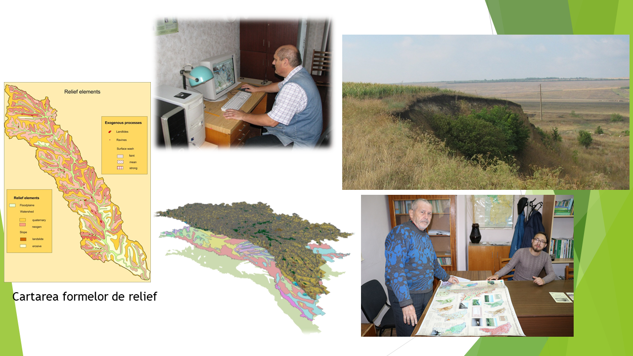
For the Republic of Moldova, the instability of the relief is specific, with the intense development of exogenous geomorphological processes such as: rolls, landslides, linear erosions and landslides, which cause considerable material damage to the economy and society. In order to highlight the conditions and factors that influence the development of processes, especially landslides, as well as to identify ways to reduce possible damage, in 1975 the Exogenous Geomorphological Processes Laboratory was established by Dr. hab., Andrei T. Levadniuk. In the scientific research process, the methods of interpreting aerial photographs and geodetic monitoring were intensively used. Over the years, depending on the topicality of scientific research objectives, the laboratory has diversified its research directions. Thus, from 1991 to 2000, the Laboratory was called Geomorphology, where studies were conducted related to the main landforms and the processes that created them (technogenic forms formed a separate category). From 2001 to 2013, it was called the Laboratory of Dynamic Geomorphology. This period was dedicated to a more in-depth study of the main dynamic processes of landform formation and their mapping, using geoinformation technologies.
Currently, geomorphological research includes two directions:
Fundamental research: highlighting the factors, dynamics and development trends of exogenous geomorphological processes, assessing the impact of these unfavorable processes on changing the potential of territorial units and their vulnerability, human activity and living conditions, geomorphological risk and environmental mapping.
Applied research: elaboration and support (maintenance) of the Geographic Information System (GIS) for different components of the environment, elaboration of thematic spatial models and digital geographical maps.
The research results serve as a scientific basis for arguing measures to prevent the activation of exogenous processes, relief modeling, for the location of economic objectives in conditions of unstable territories, the forecast of their activation in current climate change.
The research methodology is based on a series of principles - spatial distribution, time distribution; integration and application of methods of:
- geomorphological and geological-engineering mapping;
- decryption of remote sensing data;
- digital spatial modeling with the application of GIS technologies;
- statistical analysis;
- physical and mathematical modeling of exogenous processes, etc.
The main scientific results of the research activity included:
- elaboration of the complex approach regarding the evaluation of the geomorphological-engineering conditions of the territories;
- highlighting the particularities of the development and distribution of exogenous geomorphological processes;
- elaboration of the methodology for evaluating the susceptibility of the territories to the development of landslides (based on geomorphological criteria);
- identification of the particularities of the location of linear engineering objects (roads, railways, high voltage power lines, gas pipelines, etc.) in unstable regions, affected by landslides;
- proposing recommendations regarding the rational use and protection of lands with landslide potential;
- indication of the structure and creation of the database of the subsystem “Geomorphology” within the Geographic Information System with the compartments: Geology, Morphometry, Morphology, Landslides, Linear erosion, manifestation of landslide-debris, karst, mud torrents, anthropogenic forms;
- elaboration of the electronic Atlas “Geomorphology of Moldova”;
- spatial modeling of land changes under the action of exogenous relief formation processes;
- assessment of the risk of manifestation of exogenous geomorphological processes in landscapes;
- assessment of the vulnerability of the administrative-territorial units to the development of exogenous processes.
Elaborated materials:
- Map of landslides of Moldova (scale 1: 200 000);
- Map of contemporary exogenous processes of Moldova (scale 1: 200 000);
- Map of anthropic changes of the relief of Moldova (scale 1: 200 000);
- The influence of geological-geomorphological processes on the formation of geoecological situations on the territory of Moldova (map, scale 1: 200 000);
- Карта современной динамики рельефа Северной Евразии (в пределах России и сопредельных стран). Mashtab 1: 5,000,000;
- Set of maps „Republic of Moldova. The geomorphological conditions of Moldova ”(scale 1: 600 000 - 1: 2 000 000);
- Electronic atlas "Geomorphology of Moldova";
- Бассейн р. Днестр. Экологический атлас;
- Atlas. Natural and anthropogenic risk factors;
- Tourist map;
- Atlas set for middle school.
Relevant publications:
- ДОСКАЧ А.Г., ЛЕВАДНЮК А.Т., ЧЕРНОВ Г.Н. Эрозионные и оползневые процессы на территории Молдавии (сб. статей). Кишинев: Штиинца, 1978. 80 с.
- ЛЕВАДНЮК А.Т. Инженерно-геоморфологический анализ равнинных территорий. Кишинев: Штиинца, 1983. 256 с.
- ЛЕВАДНЮК А.Т., МИЦУЛ Е.З., СЫРОДОЕВ Г.Н. и др. Оползнеопасные территории Молдавии и их рациональное использование. Кишинев: Штиинца, 1990. 124 с.
- ЛЮ Ц.Ц., СЫРОДОЕВ Г.Н., ОВЕРЧЕНКО А.В., БОЛФОСУ М.С. Ландшафты Молдовы. Оценка пространственных структур и форм. Кишинев, 1998. 70 с.
- SÎRODOEV G.N. Modificarea antropogenă a reliefului şi influenţa ei asupra geosistemelor. Bul. Academiei de Ştiinţe a Moldovei. Ştiinţe biologice, chimice şi agricole. Nr. 1 (290). Chişinău, 2003. P. 122-126
- SÎRODOEV G.N. (ed.). Republica Moldova. Condiţii geomorfologice (set de hărţi). Chişinău: Iulian, 2006.
- CONSTANTINOV T., SÎRODOEV G.N., MIŢUL E., IGNATIEV L., GHERASI A. ş. a. Republica Moldova. Hazardurile Naturale Regionale. Chişinău, Tipogr. „Elena-V.I.” SRL, 2009. 108 p.
- SIRODOEV G.N., SIRODOEV I., SVIRIDOVA A. Zoning of the Anthropogenic relief of urbanized territories. Buletinul Academiei de Ştiinţe a Moldovei. Ştiinţele vieţii, 2009, Nr. 1(307). P.152-158.
- MIŢUL E., SÎRODOEV GH. Geomorfologia. În: Flora Basarabiei (plantele superioare spontane) în 6 vol. Vol. I. Bryophyta, Lycopodiophyta, Equisetophyta, Pteridophyta, Pinophyta. Resp. de red. Andrei Negru. Chișinău: „Universul” ÎS, 2011. P. 18-24.
- Landslide Susceptibility Assessment in the Central Part of Republic of Moldova. Project No: SFP-983287. Final Report. Chişinău, S.n. 2013. 52 p.
- SÎRODOEV, Gh.; MIŢUL, E.; GHERASI, Al ş.a. Factorii Geomorfologici. În: Atlas. Republica Moldova: Factorii naturali şi antropici de risc. Chişinău, 2019. P. 9-40.
In 2009, the Laboratory of Dynamic Geomorphology for outstanding achievements in the development of geographic information systems was awarded the ESRI (world-renowned company, software creator for GIS).
Research field Ecopedology:
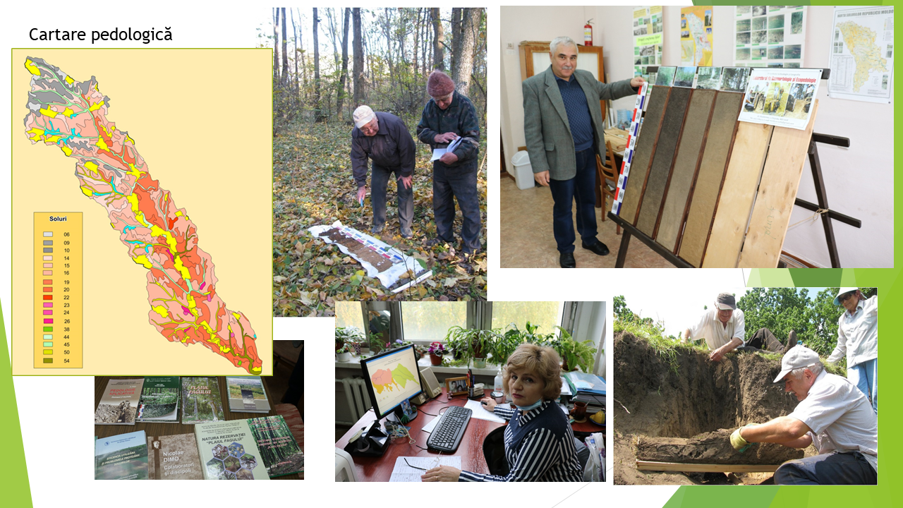
The main research directions in the field of soil ecology during the last 25 years have included: studying the laws of geographical spread and contemporary soil evolution, highlighting the transformation of the soil cover under the influence of anthropogenic activity; classification and study of soils as a basis for landfills; creating the information base and modernizing the methods of automated characterization of the ground cover; elaboration of soil maps and soil information systems on a national scale.
Currently, soil research is carried out under the project 20.80009.7007.08 "Spatio-temporal modeling of abiotic environmental factors to estimate the ecological stability of landscapes", the section "Factors and assessment of the vulnerability of territorial units to unfavorable natural processes, in the context of global changes environment”. The aim of the research is to highlight the variability of morphological indices of different soils in spatial and genetic-taxonomic aspect. The highlighted varieties will allow awareness of the variability and diversity of soil processes within different soil areas, deciphering the genetic composition of complex areas, explaining the differentiation of soil productivity in territorial units, etc.
The spectrum of scientific competence in the field of soil science includes: geography and soil evolution, soil classification, pedogeographic reasoning and appreciation of regional features of land use and protection, typification of pedoecological potential of landscapes, soil research in the geographical and geoecological environment, of soils, assessment of soil suitability, assessment of the degree of ecological stability of soils, etc.
The main results of the scientific research activity were:
- identified, highlighted and characterized the technogenic transformation of the soils of the Republic of Moldova;
- elaborated the new soil classification of the Republic of Moldova in accordance with the principles of contemporary soil science (1999, 2004);
- updated the pedagogical reasoning and the regional particularities of land use and protection (2006);
- created the database of morphological properties of soils;
- performed the general characterization of the soils and published the monograph “Soils of Moldova” (2011);
- developed and published the Soil Map of the Republic of Moldova at a scale of 1: 750 000 (2011);
- periodically characterized the current state of soil resources of the Republic of Moldova.
Among the elaborated didactic-educational materials we enumerate:
- Soil map of the Republic of Moldova (scale 1: 1 500 000)
- Soil map of the Republic of Moldova (scale 1: 750 000)
- Map of pedological provinces
- Map of pedogeographic areas and districts
- Map of pedogeographic districts
- Map of pedogeographic micro-districts
- Information leaflet "Mold Soils"
- Monographs, collections of scientific papers, scientific articles and popularization of science, booklets, recommendations (about 350 titles).
Relevant publications:
- Transformarea tehnogenetică a solurilor. Sub redacţia academicianului Andrei URSU. Chişinău, Tipografia AŞM, 1996. 104 p.
- URSU A. Clasificarea solurilor Republicii Moldova, Chişinău, 1999. 48 p. (două ediții).
- Degradarea solurilor şi deşertificarea. Деградация почв и опустынивание. Sub redacţia academicianului Andrei URSU. Chişinău, Tipografia AŞM, 2000. 308 p.
- Rezervaţia Naturală de stat „Plaiul Fagului”. Sub redacţia academicianului Andrei URSU. Chişinău–Redenii-Vechi, Chişinău, Tipogr. Ed. “Universul”, 2005. 432 p.
- URSU A. Raioanele pedogeografice şi particularităţile regionale de utilizare şi protejare a solurilor. Chişinău, Tipografia AŞM, 2006. 232 p.
- URSU A. Resursele de sol. În: Resursele naturale. Colecţia mediul geografic al Republicii Moldova, (aut. coord.: Mihăilescu C., Sochircă V., Constantinov T.). Chişinău: Ştiinţa, 2006, p. 158-183.
- URSU A. Solurile Moldovei. Chişinău: Ştiinţa, 2011. 234 p.
- URSU A., OVERCENCO A. Harta solurilor Republicii Moldova. Scara 1:750000, INGEOCAD, Chişinău, 2011.
- URSU A., BARCARI E. Solurile Rezervaţiei „Codrii”, Chişinău, Tipografia AŞM, 2011. 84 p.
- URSU A. Pedologie aplicativă. Domenii şi metode. Chişinău, Tipografia AŞM, 2011. 144 p.
- URSU A., OVERCENCO A., MARCOV I., CURCUBĂT S. Chernozem: Soil of the Steppe. În: Soils as World Heritage. Editor DAVID DENT, Dordrecht Heidelberg New York London, Springer, 2013, p. 3-8.
- OVERCENCO A. Irigarea culturilor agricole de valoare înaltă: Ghid practic. ACED Proiectul Competitivitatea Agricolă şi Dezvoltarea Întreprinderilor. Chişinău, ACED, 2015, 66 p.
Resources and skills:
The laboratory is composed of specialists with high qualification and experience, followed by training through postgraduate, doctoral and master studies, being active presences at national and international scientific events in the considered field.
At the same time, the Laboratory has a specialized unit equipped for laboratory tests in the field of soils and water as a support for basic scientific research.